Storm chaser safety: dual polarization Doppler radar analysis of the Linwood, KS May 28, 2019 tornado event
In what could have been a tragic event, two Silver Lining Tours (storm chasing company) vans drove into a tornado, rolling both vans and injuring at least 12 people. The tour group drove into a high precipitation (HP) supercell tornado in Douglas County, KS on May 28, 2019. In an attempt to witness nature’s fury up close, some storm chasers may be getting too close. ULTRA TechLife presents a scientific analysis of this event, focusing on life-saving tips for storm spotters and chasers. Many lessons can be learned from this event, and it’s not the first time this has happened. Of the 18 tornado-related injuries that day, 12 were from storm chasers that were part of the Silver Lining Tours group. When a majority of your tornado injuries are represented by storm chasers, it’s time for a discussion. May 28, 2019 reminded us all to never hesitate to seek shelter, to be prepared, and to keep our distance from HP supercell tornadoes.
This report presents scientific analysis of dual polarization Doppler radar products as well as the damage path for the tornado, putting together a picture of what happen and tips to avoid it in the future. If you like Skywarn spotter training, this article and video will be perfect for you. May 28, 2019 could have been the worst day in the history of storm chasing. Severe weather continues to attract more people driving into storms in search of a tornado. Let’s discuss what happened that day as well as some safety tips.

Major Tornado Event Presents Many Critical Lessons
There’s nothing like witnessing a monster tornado, you never forget the feeling, sounds, and what you saw. Well before my undergraduate and graduate studies, I would always enjoy case studies. Reading and watching scientists masterfully analyze what happened with advanced technology tools really blew my mind. I realized there’s a lot to learn, if we listen, and that science has a remarkable way of saving lives. This event is a perfect reminder of that fact. The new Supplemental Adaptive Intra-Volume Low-Level Scan (SAILS) weather radar strategy is really a fantastic example of scientific advancement. Throughout this analysis, I focus on weather radar products that help identify a potential tornado, especially a strong tornado – with high confidence. There are some techniques that storm chasers and spotters can also learn to help raise their level of awareness and safety, especially when it comes to monster HP supercells. It’s my pleasure to present this radar analysis/case study, primarily to discuss what happened and how to avoid it (driving into a tornado).
The Event
In the late afternoon of May 28, 2019, Linwood, Kansas was devastated by an EF-4 tornado. It was a huge, spectacular, scary demonstration of nature’s fury. But there was an even bigger tragedy — that almost happened – and it’s all on video. At least two Silver Lining Tours (a storm chasing tour company) vans drove into a tornado, just to the southwest of Lawrence, KS, around 6pm local time. Emergency officials responded to a wreck in the 500 block of E550 Road in Douglas County, Kansas. Twelve people were said to be injured. Each of them were taken to local hospitals. That day, the warning system worked, but not everybody listened. We can look at the data to see what happened that day as well as consider some things we can do in the future to keep ourselves as safe as possible from killer tornadoes.
This report will present some life-saving tips for storm chasers and storm spotters that may find themselves in HP supercell environments. It’s important to turn to science to see what we can learn after an event, especially if it means saving life and property. Science has given us so much and it’s becoming even more important for our current survival and future.
The Environment
When a tornado watch is issued for an area, people need to be alert and ready to take action. This means conditions are favorable for tornadoes in and close to the watch area. But what does this really mean? I’ll explain some of the key things that caused the tornado watch that day. Although this report focuses on the Linwood, KS tornado event as it relates to the vans rolling over, it’s worth briefly discussing the atmosphere the afternoon of May 28, 2019. This was not a perfect severe weather setup, but the ingredients were there to suggest the environment was somewhat favorable for a few significant tornadoes. A 40-50 kt deep layer shear area increases by later that afternoon in eastern Kansas. A triple point approaches the area with a marked dryline just west of the I-35 span. These features are often the focal point for storm initiation and a driving factor for assisting storm updrafts. A few supercells had developed ahead of this and began moving northeast.
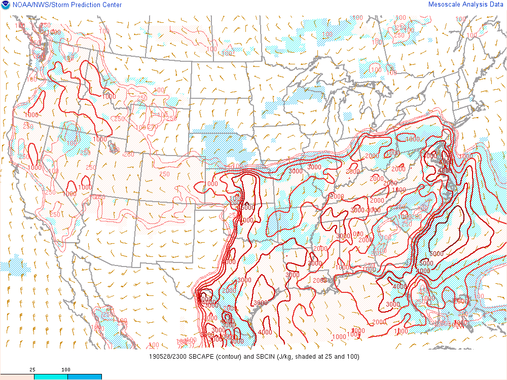
CAPE was around 2,000-3,000 J/kg (Figure A) and there was some forecasted increase in upper-level accent by 7-8pm, meaning uplift would be more favored around that time. This means the atmosphere would supply a sufficient enough of energy to fuel severe storms. In addition, multiple areas of uplift would favor updraft development.
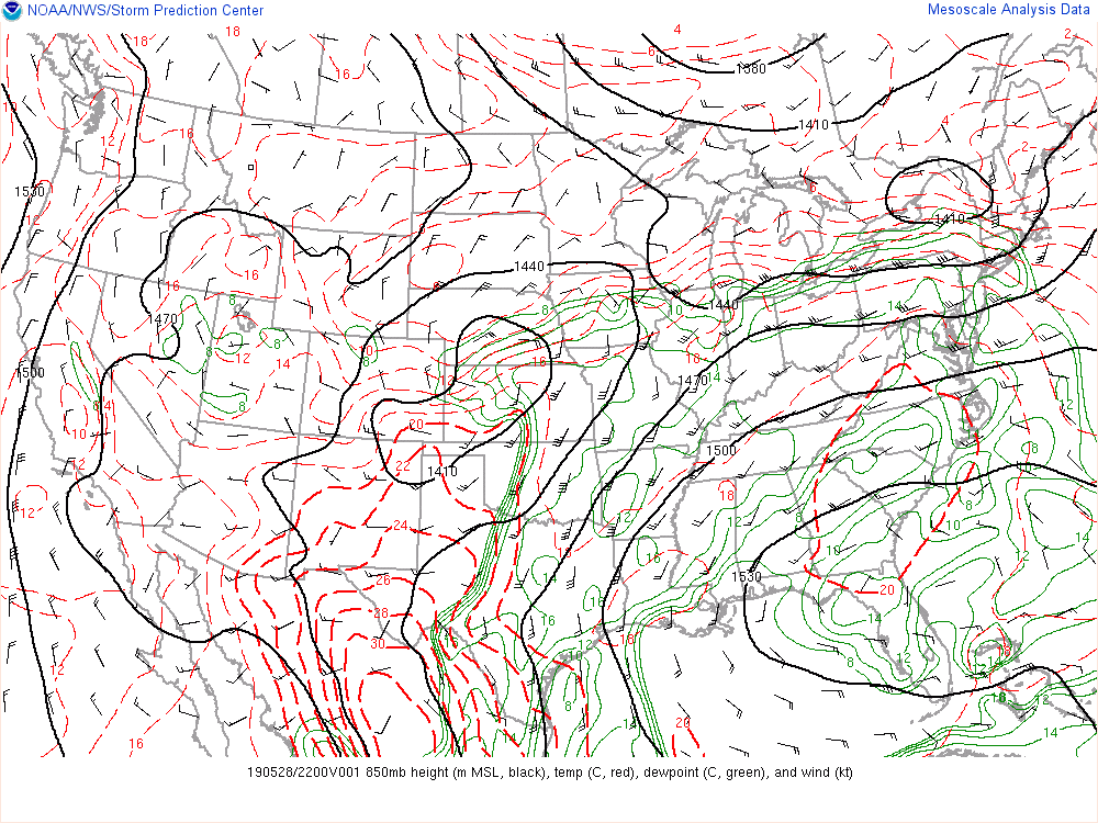
The 850 low level jet was initially not impressive, around 30 kts (Figure B), but was also forecasted to increase by 7pm-8pm. Severe storms often occur near the low-level jet, so we were watching this area on that afternoon.
The surface analysis (Figure C) around 7pm shows an evident low level moisture tongue, which extends well into northeastern Kansas with surface temperatures around 77 degrees and 68-70-degree dew points around much of the area. In addition, storm-relative helicity (SRH) parameters were forecasted in excess of 200 m^2/s^2, near a threshold where we may see an increased tornado threat with supercells. As the triple point moved closer towards the Kansas City metro area, especially with the location of the warm front, and forecasted parameters, enhanced convergence/uplift would be promoted. This meant there was a window when we would likely see a higher tornado threat — approximately between 5pm and 8pm that late afternoon. The 9-10 km storm-relative winds around 20 m/s with ample low level moisture tend to favor HP supercell types, but that doesn’t mean other classic types would not be possible.
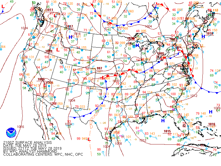
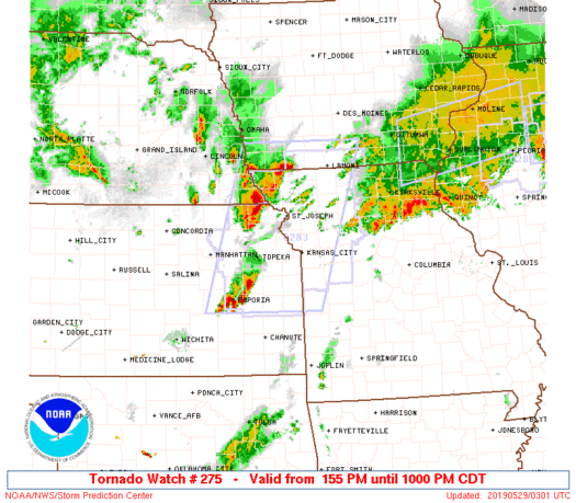
A tornado watch was issued around 2pm that afternoon, based on the details above (Figure D).
This wasn’t a high risk day, but never rule out a single significant tornado event – that’s all it takes to destroy an entire town in seconds.
Analysis: 4-Panel Storm Interrogation
Doppler weather radar is awesome. Over the past few decades, I’ve personally witnessed this save millions of lives — as a forecaster, at police and EMS command posts, for FEMA, during RACES nets, as a Skywarn net controller, pilot, and storm chaser. In fact, it’s saved my life before. We can take a look at multiple radar products from that day as a way to see what happened and discuss learning opportunities.
The following is a description of radar data around the time of the storm tour vans being impacted by a tornado that afternoon in Douglas County, KS. Analysis will examine a 4-panel radar data set, storm chaser video, and the official tornado damage path for May 28, 2019. The areas of interest include Douglas, Wyandotte, Johnson, and Leavenworth County, Kansas.
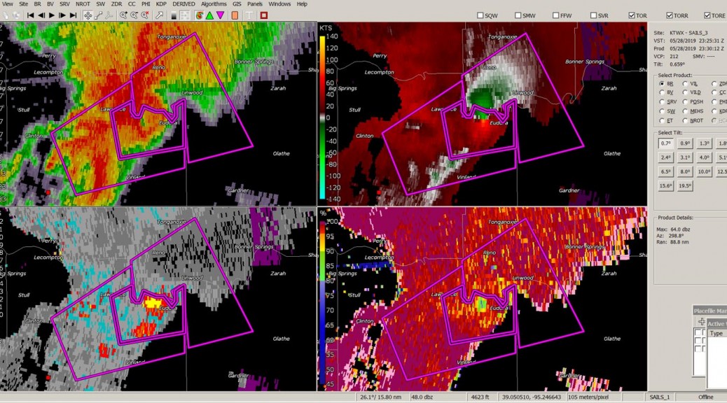
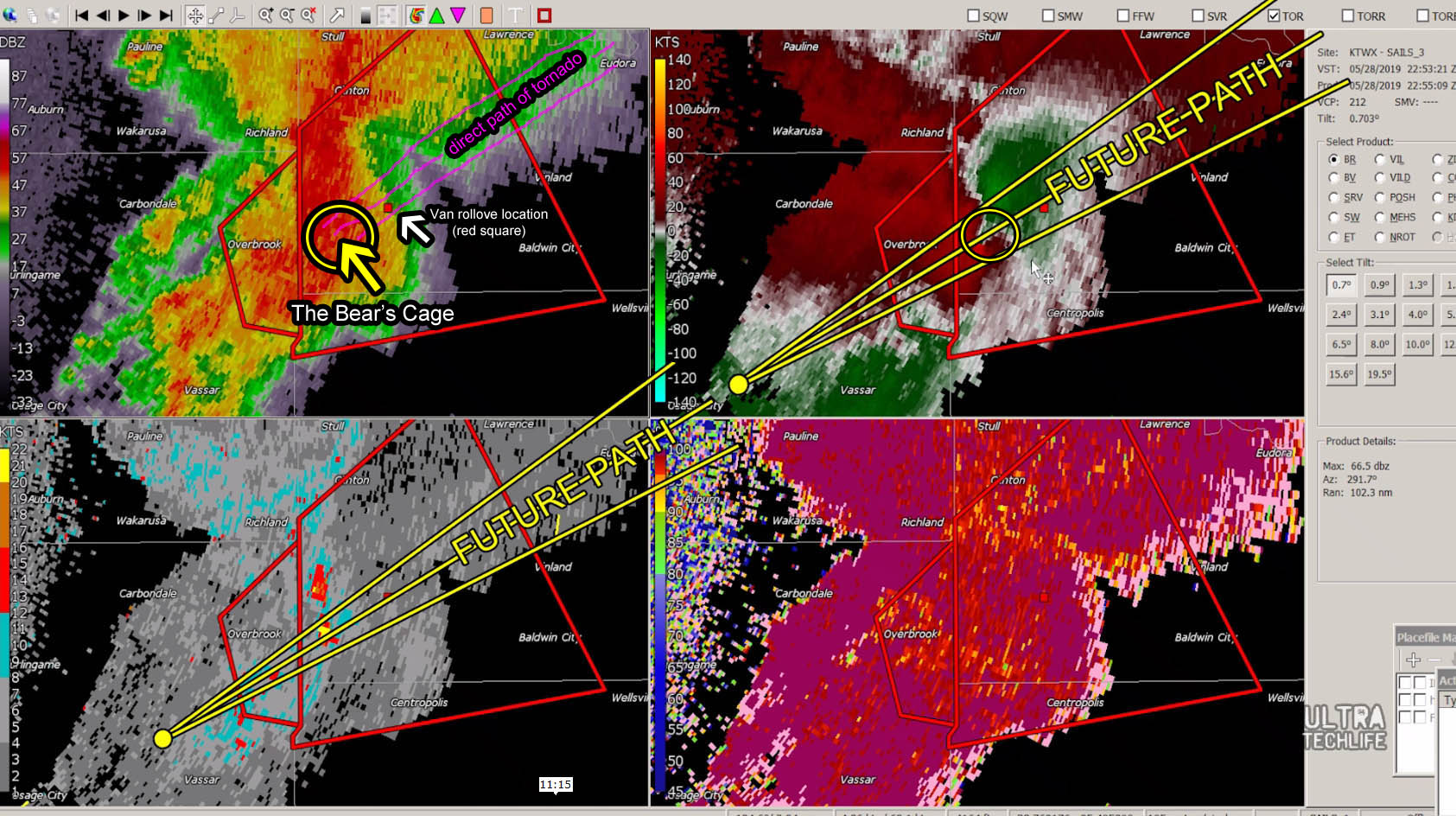
Using KTWX level-II dual polarization SAILS radar data, a 4-panel storm interrogation is performed. Level-II data included high resolution reflectivity of the lowest tilt (BR 0.7), base velocity (BV), spectrum width (W), and correlation coefficient (CC). The first volume starts at 22:40Z (Figure E) and indicates a shape on reflectivity consistent with an HP supercell (kidney bean). A tornado warning already exists at this time for Osage County, KS. Within minutes, a tornado warning is issued for Douglas County, KS and the warning polygon is the first hint at where the National Weather Service believed the tornado would be located. Radar data is pretty consistent with this location — the primary indicated mesocyclone as indicated on BV south of Overbrook, KS. A marked area of high spectrum width is co-located with a evident couplet south of Overbrook. The storm is moving approximately northeast in direction, at 35 mph.

By approximately 22:53Z (Figure F), the leading edge of the intensified HP supercell precipitation core approaches within a few miles of the storm tour group’s vans in Douglas County, KS. An evident, somewhat stronger velocity couplet is just south-southwest of their location, co-located with persistent high spectrum width, and now slightly tighter than before, headed directly for their location. A rain-wrapped tornado is already occurring at this point, which is what prompted the initial tornado warning (radar-indicated from KTWX).

Examining multiple radar scans as well as a cross section, seeking the location of a weak echo region (WER), and then animating this, it becomes very evident that they are in the direct path of where one would expect a tornado to be occurring – directly underneath the primary area of stronger rotation, directly into a core of heavy precipitation. Multiple volume scans show the WER moving in a relative southwest-to-northeast direction, consistent with other co-located products (they were in the direct path). According to radar, they were on a direct path with the strongest area of rotation/updraft region.
At some point, around 23:00-23:04Z (Figure G), the vans are impacted by an existing tornado. Based on the 4-panel and damage estimates, the van was impacted by winds anywhere from 90-115 mph, which caused them to roll (estimated). This was an existing tornado and radar data seems to indicate a new mesocyclone may have formed just to the northwest, downstream, almost immediately after the weaker rotation dissipates (< 0.15 miles south of the new mesocyclone, just south of the Lonestar area). Cyclic supercells are known to produce multiple mesocyclones, typically within 1-3 miles of the original mesocyclone, which appears to be the case here. This storm likely produced several mesocyclones.

By 23:11Z (Figure H), radar data shows a rapidly intensifying, new, stronger tornado just west of Pleasant Grove, KS. BV data indicates a 116 kts gate-to-gate shear couplet, co-located with high spectrum width and a very evident debris ball (CC < 0.80). This would continue strengthening into what would be the stronger EF-4 tornado that hit Linwood, KS. The 23:12Z BV shows 125 kts gate-to-gate shear with a growing debris ball (CC < 0.80) and also co-located with a marked high area of spectrum width (W > 20 kts). The 23:14Z scan confirms persistent strengthening with approximately 145 kts gate-to-gate shear. Persistent co-location of major tornado indicators increases warning confidence at this point.

Around 23:39Z, continued co-location of high W, low CC, and a strong couplet (now ~ 157 kts gate-to-gate) is evident just west of Linwood, KS (Figure I). This major tornado continues to head towards very populated areas in Wyandotte County, KS. A tornado emergency exists at this point.
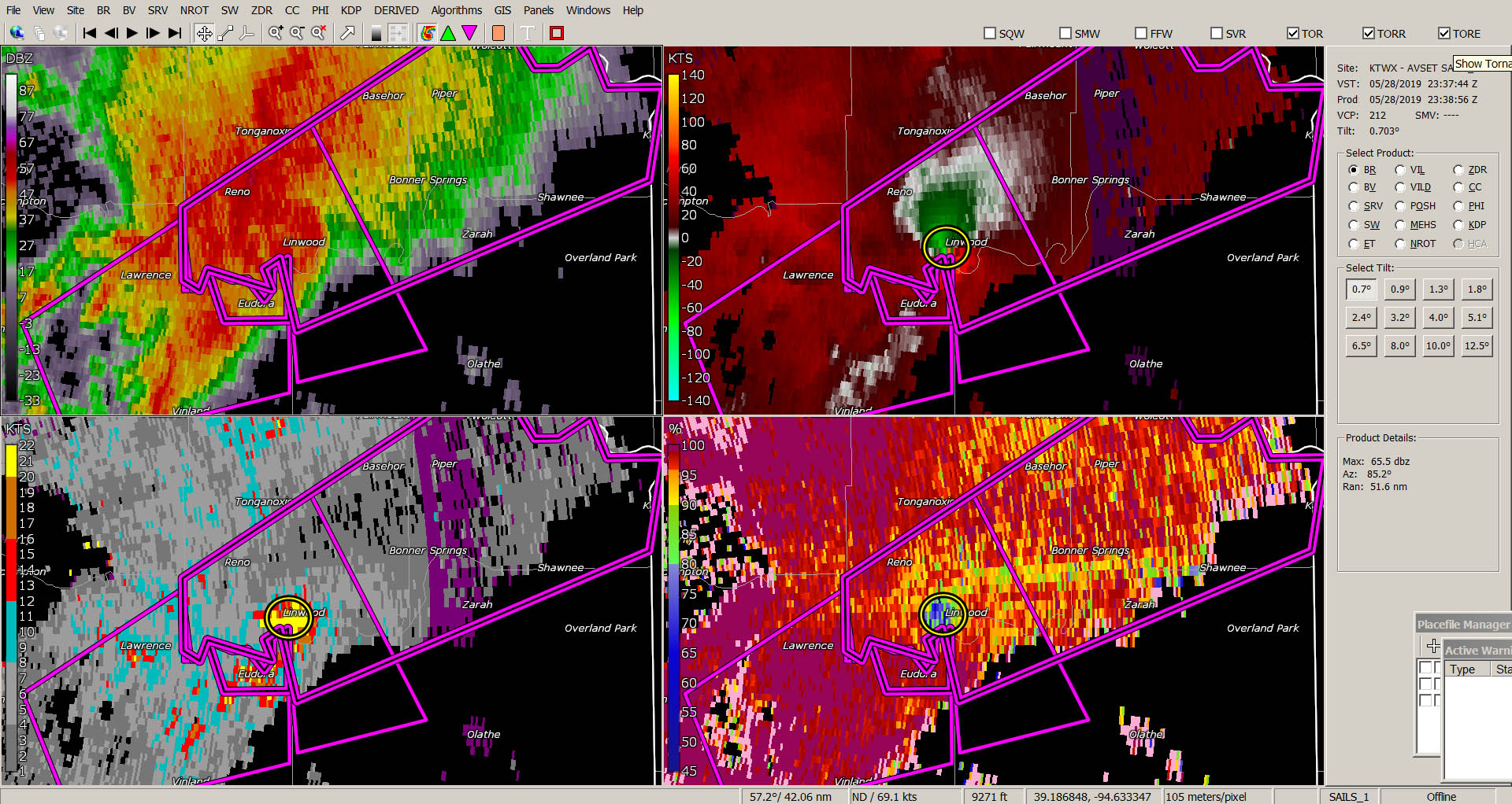
By 23:53Z, the storm rotation weakens and the tornado dissipates. Tornado debris falling in the air is reported by numerous storm spotters and chasers at this point (all the way to Bonner Springs, KS). Debris signature is noted on radar just west of Bonner Springs, KS (CC < 0.80). A marked area of high spectrum width is noted as co-located with the mesocyclone, low CC, and in the appropriate, expected portion of the storm. This has been persistent since the formation of the stronger tornado.
It’s important to note that even though SAILS may decrease scan times (< 4 minutes), much can be lost in that time, and we still can’t see smaller details or what’s happening at the surface. However, radar gives us clues, generally at the low and mid-levels as to what’s going on. In this case, we can say with confidence that they were in the path of an existing tornado, exactly where you would expect to find a tornado within the core of an HP supercell. Radar presented numerous clues and warning signs well before the vans were impacted.
Damage Path
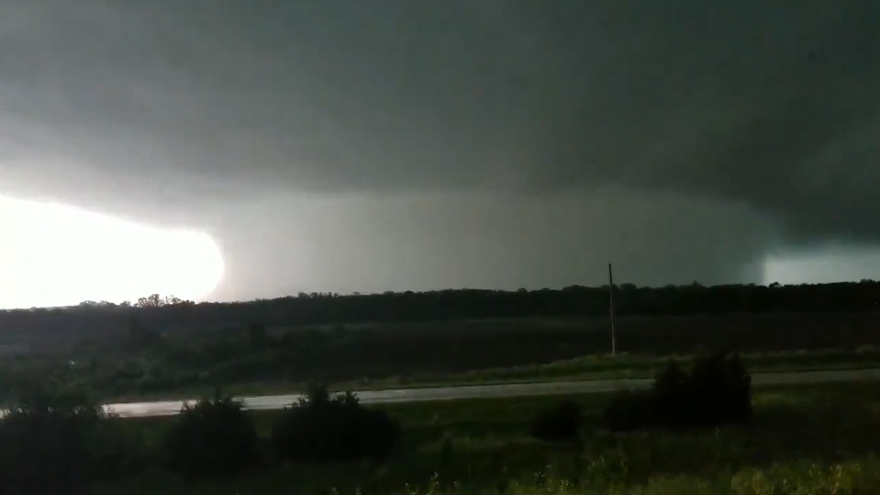
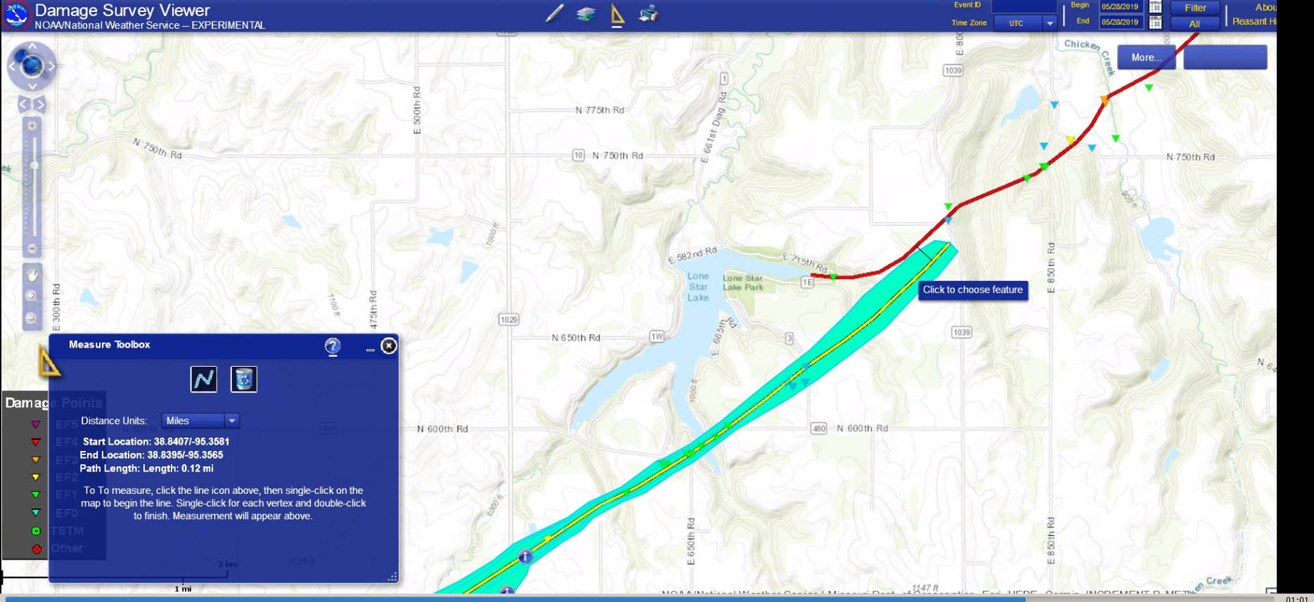
The tornado damage path (Figure J) as well as video from inside the storm tour van seem to coincide with radar data. It is consistent with a scenario involving a dangerous attempt to core punch (drive into heavy rain that surrounds a tornado) directly into the bear’s cage (region of a tornado). This was an HP supercell that likely involved heavy precipitation that obscured the view of the tornado. Visibility was almost zero — as seen in the van video. The tornado damage path coincides with the main path of the storm’s mesocyclone signature (southwest to northeast). A previous mesocyclone decays around the Lonestar Lake area, where less than 1-mile north (approximately 0.18km distance), a new, stronger mesocyclone rapidly forms. A new, stronger tornado rapidly develops and strengthens into what would be the Linwood, KS EF-4 tornado (Figure K).
The evidence strongly points to Silver Lining Tours driving into an existing rain-wrapped tornado, despite having knowledge of the danger of a tornado existing. This was a mistake that could have cost numerous people their lives. These were extremely dangerous circumstances, particularly made worse by involving van loads of people.
According to the Enhanced Fujita (EF) tornado damage scale, the Linwood tornado was rated around EF-3 to EF-4. This means the winds were between 136 to 200 mph at its strongest points.
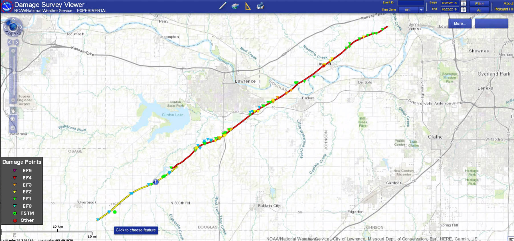
This was not a satellite tornado event, nor was the tornado any significant distance away from the evident overall mesocyclone on radar, which is confirmed by damage assessment data. Again, the mesocyclone is the broader sense, and the tornado is the actual event. The tornado was within the radar-indicated rotation area – as expected.
Cyclic supercells are known to, can, and do produce multiple mesocyclones and tornadoes. This was not an unexpected event, it involved the storm tour group getting too close to the main area of rotation that was obscured by heavy precipitation, hence the name “HP” supercell. The conclusion, according to the data and their own video is — they drove into an existing tornado.
The damage path indicates an existing tornado formed in Osage County, KS and tracked towards the northwest (SW to NE line). No other tornado was occurring. It would seem, scientifically, this didn’t meet the criteria of a “satellite tornado”, which generally 1. occurs with an existing main tornado, 2. orbits the path of the main mesocyclone rotation sense. A single, distinct damage path exists for nearly 8 miles, until the tornado hits the vans (Figure L). It was an existing tornado that was doing damage for some time, which is also consistent with them suddenly driving into debris falling in the air (in their own video). Up to this point, no other tornado was occurring. The damage assessment only shows one distinct path, all the way to the point of impact with the vans. This was an HP supercell, and no matter how you look at it, they got too close, they drove into a rain-wrapped tornado, resulting in numerous injuries, and this was preventable. A satellite tornado would have existed at the same time as a larger tornado and would generally orbit the main tornado. Again, this was already a tornado-warned HP supercell, so the element of surprise shouldn’t exactly be on the table, since the events unfolded in a general area where they are to be expected. Unfortunately, getting too close means little to no time to react. We should learn from this and keep our distance, especially van loads of people.

Numerous, potentially deadly mistakes were made, including core punching directly into the “bear’s cage” of an HP supercell that had an existing tornado warning out for it — with a van load of tourists. Had they driven into the stronger tornado, just a few minutes/miles difference, they probably would not have survived the experience. They certainly wouldn’t survive driving into an EF-4 tornado with a van load of tourists. The lethal projectiles from winds that high would likely kill everyone. They were lucky and this should be a learning experience for everyone.
Supercells are awesome to see, but you have to understand just how powerful they are and recognize their unique dangers – you must keep your distance.
Cyclic Supercell Tornadoes
A supercell is a long-lived, self-sustaining special type of thunderstorm that contains a deep, persistent mesocyclone. It requires a unique environment, including adequate wind shear, instability, moisture, and lifting. Instability is the tendency for air to continue to rise once displaced. A cold front can provide a lifting mechanism, causing a parcel of air to begin to rise up high into the atmosphere. Winds change with height, providing directional shear. Moisture adds to the instability, the tendency for air to rise by itself. The supercell storm thrives in these environments and because of its structure, it tends to live much longer than an average thunderstorm. Supercells are responsible for our most deadly tornadoes. Thankfully, dual polarization Doppler weather radar and advanced weather model prediction tools have enabled meteorologists to make better watches and warnings, saving a lot of lives and property.
Supercells have complicated internal storm structure that continuously interacts with a series of differential fluid flows in the vertical and horizontal extent. This monster type of storm can come in many forms, including a Classic, HP, or LP. Classic supercells appear as a hook echo on radar and have very impressive, highly visible storm structure on the ground (as a storm spotter). On the other hand, a high precipitation (HP) supercell appears often as a kidney bean shape on radar and often hides tornadoes, since they are typically rain wrapped, which also means it’s a deadlier type of storm. Low precipitation (LP) supercells rarely produce tornadoes and have almost no precipitation visible at the base. The HP supercell is of particular interest to monitor because of the hidden dangers.

Meteorologists often look for radar indicators that tell them where a mesocyclone may be located. A mesocyclone is a storm-scale rotation within a convective updraft. In the case of a supercell, a tornado is an even smaller rotation event that occurs within the area of a mesocyclone. There are specific wind shear, vertical extent, and persistence criteria that must be present in order to be called a true supercell mesocyclone.

Scientists have known for some time that cyclic supercells present a multiple mesocyclone threat. These mesocyclones continuously evolve as the rear flank downdraft (RFD) of the storm speeds up, eventually catching up with the forward flank downdraft (FFD). It’s often observed that the initial mesocyclone takes a long time to mature, but future mesocyclones can quickly spin up as this point of occlusion moves downstream. This means that numerous tornadoes can be produced. In fact, it often means an original tornado weakens and a new, stronger tornado, can form close to the previous location. Typically, if an old mesocyclone weakens and a new one forms, it’s within 1-4 miles of the original circulation area. That’s pretty close, and certainly not surprising, it’s part of how the self-sustaining storm reacts to a dynamic environment.
Live-Saving Tips
First, it’s generally not a good idea to be driving into an HP supercell. There’s a lot of precipitation and that means you can’t see anything, including a killer tornado coming your way. However, there will always be storm spotters and chasers seeking the biggest storms. We can use science to determine some techniques that could keep us safe. These strategies have been time-tested and may allowed you enough time to escape – or avoid getting yourself too close.
Paint an imaginary line in your head (Figure M), similar to a hurricane “cone of uncertainty”, which is a general area of where a tornado is most likely to occur – even if it isn’t occurring right now. It’s not just a straight line, you give yourself a buffer of several miles because a new circulation/tornado can form up to a few miles any direction of the original circulation. Never lose situational awareness. A supercell can intensify, change speed and direction – so can a tornado – and sometimes in just a matter of seconds.
Situational awareness means keeping your distance so you have time to identify trouble and react. Keep in mind that storms moving into a favorable environment may change shape, size, intensity, and direction. This also means that a storm might not be producing a tornado right now, but it could be moving into a favorable environment in the near future. Never let your guard down.
The most important rule is to keep your distance from HP supercell rotation center, precipitation cores, or more commonly an area known as the “bear’s cage.” It’s called that because it’s just as dangerous as being put into the cage with a wild lion or bear (tornado). It’s a place you don’t want to be, especially for a strong tornado. You will not survive a significant tornado in a car – and this becomes even more true for a van.
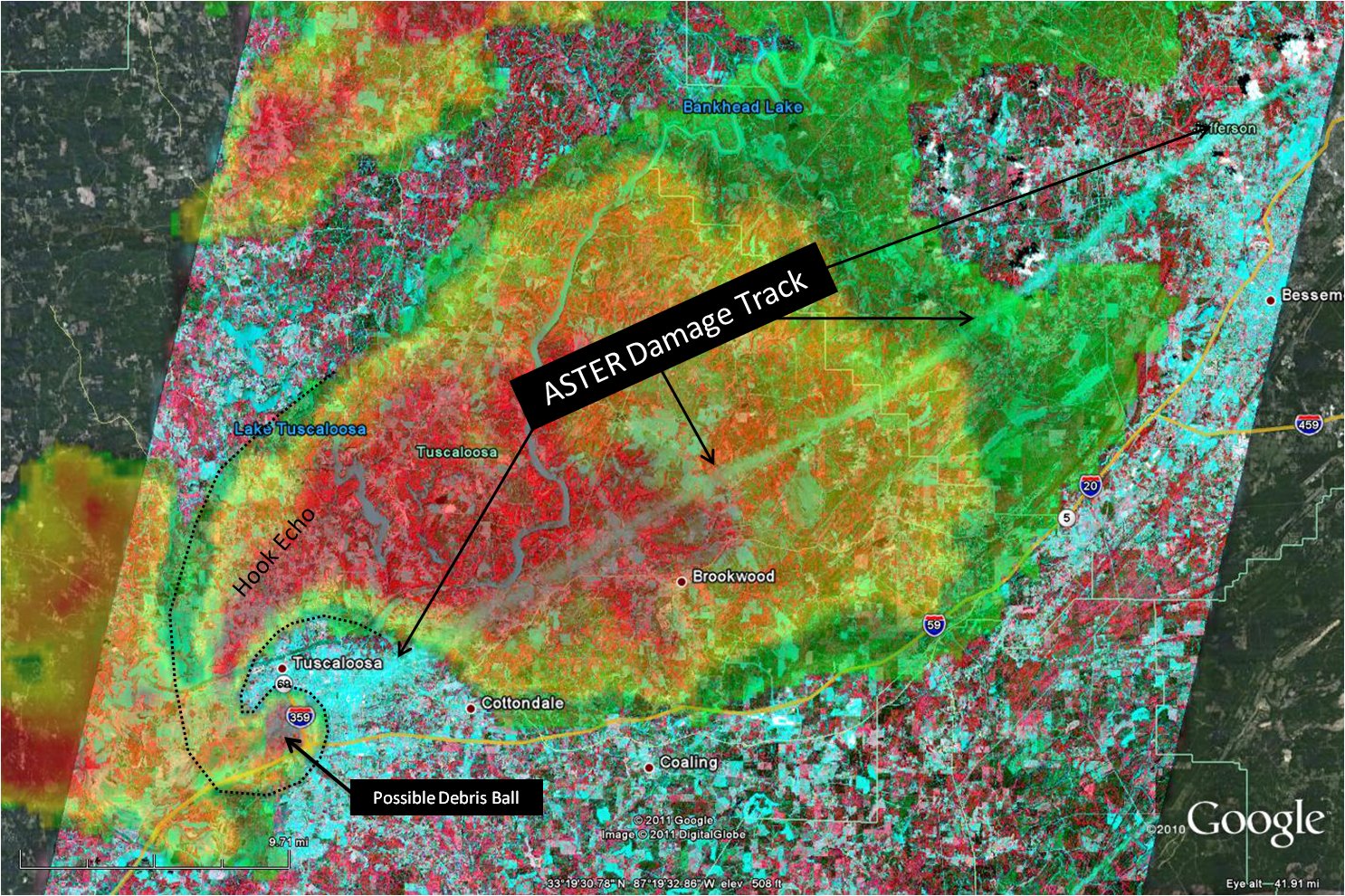
Amazing Image: Check out the path of this single supercell during the April 2011 tornado outbreak (Figure N). A single supercell lasts several hours, several states, producing numerous tornadoes. The southwest-to-northeast do-not-trespass imaginary line can be visualized. Remember, a cyclic supercell can produce a tornado at any time, sometimes a few miles away from the old circulation area. This should never be a surprise.

We can look at the behavior of supercells to determine their future paths. Looking at historical damage paths, it’s often a southwest to northeast line (Figure O), representing the path of the main storm circulation. Directly below that would be the damage path of a tornado. Scientists can often overlay helicity and other data right on top of this to confirm this is the most likely area for a tornado. You can imagine this line on much older case studies as well (Figure P). You should never trespass this imaginary line. You should never drive directly into the main circulation area (into a couplet), especially in the case of an HP supercell.

Many storm chasers wonder what “too close” means. It’s risky just to leave your home or drive on a clear day, life is full of risks. But the idea is to reduce them as much as possible. Never get too close.
But what is too close? That’s a matter of two things: your ability/time to recognize the danger and ability to escape. If you don’t have enough distance/time to recognize the threat and escape — you’re too close.
Bizarre Remarks
Rather than simply admit a mistake, admitting that it’s never a good idea to drive directly into the main area of rotation in a tornado-warned HP supercell, specifically a strong radar velocity couplet (suggesting an imminent tornado), with near zero visibility, and a van full of tourists, Silver Lining Tours seemed to make some bizarre statements, such as this one:
So don’t educate anyone as to what’s fake? This lack of transparency makes the situation look worse. In addition, this is not the first time Roger Hill and his group narrowly escaped being killed by a tornado. Numerous media interviews, such as this KSPR report, highlighted his escape from the 2011 Joplin killer tornado:
He recounts those terrifying moments:
“I remember looking in the rear view mirror and I could just see transformers just going, just exploding and it was getting closer, closer, closer and we were stuck at a red light because it was near rush hour in Joplin and so we were stuck at all these traffic lights and you could just see this thing getting closer and closer and that’s at the point when I said, we’re either going to run all these red lights or we’re toast.”
Numerous reports describe the same Roger Hill-associated storm chasing group getting too close, nearly getting killed, and suggesting to others that they “don’t even stop” and “run all these red lights or we’re toast.” This behavior is not safe or smart, especially on the part of tour operator with van loads of people. We’ve had people killed due to storm chasers running stop signs and red lights. Once again, this was an HP supercell event and another example of getting too close and almost getting everyone killed. Hopefully, they will listen to science, accept some level of responsibility, admit their mistakes, and avoid doing it again in the future. Next time they might not be so lucky.
Unnecessary Risks
Some first responders were also upset that the Silver Lining Tours rollover tied up their resources – and rightfully so. Bad behavior gives other storms chasers a bad name. Some do not understand the seriousness of this event – we almost had 12 dead people in a van because of some obvious mistakes. The video shows them driving into a tornado. At one point, just before the van is pushed over, someone can be heard saying, “debris falling from the sky”, and given their location, this was nature’s last warning sign of imminent danger.
Another witness, Gwen Rigby from Santa Barbara, was inside one of the vans that drove into a tornado. She told a newspaper:
Along with the radar data and damage path information, this interview would also suggest the tornado risk was not a surprise to the tour operator and for some reason they continue to basically drive into a tornado. There was no significant difference (north or south) in distance regarding the general mesocyclone location on radar from the vans impact location. They were clearly hit by an existing tornado, not a satellite tornado, certainly not an unexpected, out-of-nowhere, surprise tornado event. They made an extremely dangerous decision to drive into a rain-wrapped circulation area, eventually getting hit by an existing tornado.
Lessons Learned
We can learn a lot from the Linwood, KS tornado event.
It’s never a good idea to drive directly into the main area of strong rotation within an HP supercell, especially with near zero visibility, and especially with a van load of tourists. Have some major respect for the power of nature and keep your distance from HP supercells – they mean business.

Having an imaginary “do-not-trespass” line in your head, similar to a cone of uncertainty for hurricane forecasts, can help you stay away from danger. It’s not worth taking unnecessary risks. This is not the first time this chase group almost got themselves killed, it also happened during the Joplin, Kansas tornado event. There’s a video on YouTube showing the same habit almost getting another van full of tourists killed. Having the best, highest resolution data is also key, if you’re going to be driving a van load of people anywhere near a tornadic supercell. Without adequate situational awareness, getting very close to HP supercells means a higher risk of death for storm chasers.
Additional Thoughts
Skip Talbot also produced a video regarding this event. Many were baffled that there would be any argument as to whether this event was preventable or not, but there were a few people that bent over backwards to defend Roger Hill/Silver Lining Tours. A meteorologist (Jon Davies) took issue with the facts of this case, but we believe in full disclosure and that means pointing out his existing financial relationship with Roger Hill, which is clearly a conflict of interest when attempting to be free from bias and personal connections in an investigation matter. Davies should have clearly disclosed his financial relationship with Roger Hill. Given the radar data, spotter reports, news media coverage, and survey data, it’s hard to argue that this was a surprise, nobody could have known where the tornado was, or that meteorologists didn’t know there was possibly a tornado because it was a rapidly evolving situation.
The notion that this event was unexpected or nobody could have known where the tornado would be is demonstrably false. There was an existing tornado warning well before the vans ended up driving into an existing tornado. The warning polygon clearly indicated the danger area well before the vans drove into a tornado. News media knew this was an HP supercell before it entered the area. The KC NWS, TV meteorologists, etc. — all were on-air saying this was an HP supercell. During the entire event, radar clearly showed the area where one would expect to see a tornado. We provided over an hour of advanced warning time for the cell that produced the Linwood, KS tornado. The story about a satellite tornado was misleading/clearly not the case. News interviews also alleged Hill knew visibility was bad before diving into the tornado, as one of his guests told the media, but that they were going to attempt to get in front of the tornado anyways. We linked to the interview. A previous “too close” to an HP supercell encounter also happened with Roger Hill’s storm tour group during the Joplin tornado event — where they also *almost* got killed.
Merging mesocyclones is a subject, but previous case studies are irrelevant in the sense that they do not provide a valid argument for driving van loads of tourists into an HP supercell tornado-warned storm, since the visibility will be low and dangers would be high. These thoughts lead many meteorologists to believe what happened in this case was unnecessary, dangerous, and the vans rolling was preventable. Many have commented that to this date, a small group of people refuse to acknowledge any wrong, that there is no accountability as to what happened, that this was a pattern of behavior that happened before, and that this should be a learning experience because storm chasers have got too close before – and died. Hopefully, storm spotters and chasers will learn from this event so that a tragedy like Tim Samaras’ fate can be avoided.
This was a very significant learning event for everyone. Many people were seconds away from death. This strong tornado dissipated just to the west of the Kansas City metro area. It should be a reminder to be prepared for severe storms. Some people also didn’t seek shelter, despite being told a major tornado was headed their way. It’s never a good idea to hesitate, especially with numerous confirmation reports, helicopter video, strong radar indications, and numerous meteorologists stating “you will die if you don’t leave your mobile home.” This event could have been much worse. We should all learn from it.
It would seem some have not learned the harsh lesson from the May 31, 2013 El Reno, Oklahoma tornado event. Tim Samaras, Paul Samaras, and Carl Young got too close to a tornado and lost their lives. Hardly anything was left after their vehicle was tossed by a very strong tornado.

This is also proof it’s not just “amateurs” but also “veteran” storm chasers that are just getting too close. People are free to do what they want, but there’s just no reason to purposely get so close with a van load of tourists.
Warning about storm chasing: I’ve had a few people mention how cool it was that some people drive into tornadoes, as if it’s a good idea or something they might attempt to do in the future — all because they saw someone else do it. Many of them do not fully understand the danger involved in accidentally or purposely driving into a tornado of any significance. Making a mistake alone is one thing, but van loads of people make it an even bigger issue. Since the death of Tim Samaras and others, this is an issue I’m sure he would want us all to discuss. Storm chasing is awesome, but dying while storm chasing isn’t awesome. It’s extremely important to emphasize the seriousness of an event like this. Storm chasing is an exciting hobby, but you should learn about storms and this hobby before you try it for yourself. Attending a single storm spotter training seminar simply isn’t enough to safely chase storms. I will always encourage people to live life to the fullest, including getting involved in storm chasing. Life is full of risk, but part of being smart is to reduce as much risk as you can. This is why science education is so important, it could save your life.
On a positive note, and to conclude this article, science is just awesome. Advances in technology and opportunities to apply it and save lives is just awesome. Nature is awesome — and observing storms can be a really unique, exciting, memorable experience -– but do it as safe as possible. Consider science, learn from our mistakes, and have a respect for the atmosphere, because these HP supercells are nothing to play around with – be safe out there.
Sparking an interest in science. One other thing to think about. Sometimes major severe weather events spark an interest in science. That’s great. Maybe this event will spark an interest in science to someone that experienced the Linwood, KS tornado, or maybe you’re reading this article, or you see the documentary video. I’ve always enjoyed studying severe weather events. My undergraduate and first graduate degree major was meteorology. I’ve been chasing storms since the 1990s — and it’s all because of science. It was my deep interest in science that sparked my storm chasing hobby and eventually led to my drive to become a professor. I’ve used life-saving techniques from my meteorology education with EMS, police, fire, FEMA, as a Skywarn net control operator, and as a pilot. These events are great educational topics for meteorology students – they see science applied in a real-life scenario. As an earth and atmospheric science professor, I always to try share educational opportunities, especially if it might save lives in the future. Tornado events present a good learning opportunity because of the remote sensing tools we have. More scientists should do what they can to share important information with the public.
Site Note: The author of this article thinks storm spotter training should (from now on) include a special few minutes to focus on the dangers of HP supercells. Specifically, keeping your distance, what to look for on radar, and how this looks in the field (you’re hit before you know it). We could potentially save lives by educating more people on the nature of cyclic supercells and HP supercell tornadoes. One final thought… much of the time, storm chasers face dangers from traffic, rather than the actual storm itself. It’s important to focus on traffic safety, especially during severe weather. Tornadoes aren’t the only thing that could kill you.
*If you like unique science and tech content, check out and follow us on our new social media. Tip the author, check out our sponsors, and stay tuned for more cool stuff. Be sure to also share our videos and articles. Thanks for your support.
Special thanks to everyone for sharing their tornado photos and videos on social media, it’s being shown to thousands of students and hopefully a lot of storm spotters and chasers, likely resulting in lives saved.
More about author.